|
|
|
|
|
This page last updated February 16, 2024 |
At times, San Antonio's addressing system can seem arcane and bewildering, and the system used on its two loops are no exception. To start with, both Loop 410 and Loop 1604 use different naming and numbering systems. Once you've mastered that, you come to find that the demarcation between the segments is not cleanly delineated. If that wasn't enough, the numbering pattern is not always consistent even on the same loop.
So let's take a look at each loop individually below.
|
ADVERTISEMENT |
Loop 410
Of the two loops, Loop 410 has the easiest basic layout to understand. It's divided into four quadrants: NW, NE, SE, and SW. So it can help to visualize it as a diamond:
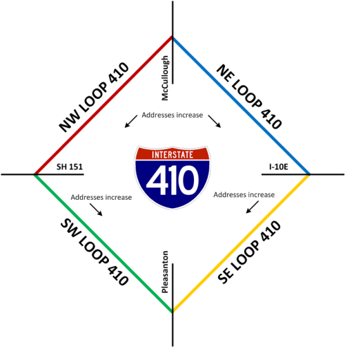
It's important to understand that the dividing lines shown above for each segment are approximate. For example, there is at least one NE Loop 410 address west of McCullough. This is because Main Ave. is actually the dividing line, but since Main does not extend all the way to the Loop, the addressing is based on the imaginary extension of Main.
The house numbers for NW and NE segments starts at the north and increases southward. Numbers for the SW and SE segments, however, also increases southward. So the numbering for SW Loop 410 resets near SH 151 and increases from there, and for SE Loop 410, the numbering restarts near I‑10 East. On NW and NE Loop 410, the addresses essentially start at zero instead of 100 like on typical numbering plans, but the numbers appear to start with 100 for the SW and SE segments.
On the South Side, part of the Loop 410 access road is actually Chavaneaux Rd., so that street's numbering is used there. On the northeast side where Loop 410 and I‑35 run concurrent, I‑35's addressing is carried through.
For the directional indicators on the highway itself (i.e. northbound, southbound, etc.), the dividing lines are mostly in different places: I‑35 on both the north and south sides of town, I‑37 on the southeast side, and Bandera Rd. on the northwest side. So for example, westbound Loop 410 becomes southbound Loop 410 at Bandera Rd.
Loop 1604
Loop 1604's basic layout is quite a bit more complex, although when you break it down, it's not quite as intimidating as it might initially seem. First of all, the loop is divided into four quadrants: North, East, South, and West. However, each quadrant is then split into two halves: West and East, or North and South. So it helps to think of each quadrant as its own street with directional divisions. For instance, just like Commerce St. is divided into East and West halves, North Loop 1604 and South Loop 1604 are also divided into East and West halves. Similarly, just as Zarzamora St. is divided into North and South sections, so are West Loop 1604 and East Loop 1604. So it might help to visualize Loop 1604 as a square with each side then divided in half:
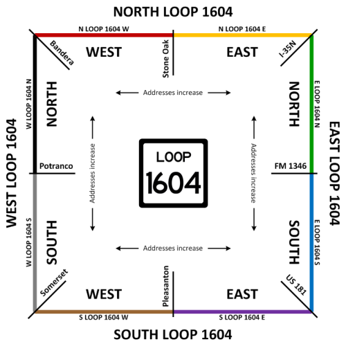
Again, like with Loop 410, the dividing lines for each segment are not exact, so some numbering may "bleed over" the streets shown. Fortunately, unlike Loop 410, the numbering plan is much more consistent on Loop 1604. The numbering starts in the middle of each quadrant and increases outward, just as it does for Commerce and Zarzamora streets.
However, the naming convention for Loop 1604 can get quite confusing in a hurry. The rule is that the quadrant name comes first and preceeds "Loop 1604"; the directional half is then tacked onto the end. This, of course, is different than regular street names like Commerce and Zarzamora where the directional half is prefixed, e.g. East Commerce and South Zarzamora. So 1000 West Loop 1604 North would be on the west quadrant of Loop 1604 not far north of Potranco, but 1000 North Loop 1604 West would be on the north quadrant of Loop 1604 a short distance west of Stone Oak. Those are quite a ways apart, so you can see that the order of the directional markers is quite important!
Complicating all of this is the fact that most folks with addresses along Loop 1604 don't understand this addressing system and instead list their addresses more simply, although technically incorrectly. It's not uncommon see addresses like 1000 Loop 1604 W or 1000 NW Loop 1604. The post office usually is able to find them because of their ZIP code, so that can also be helpful in narrowing a location down if you have that; just include the ZIP code with the address when searching in your favorite mapping program or GPS.
As for the directional indicators on the highway itself (i.e .northbound, southbound, etc.), the dividing lines are mostly the same as those for the addressing with one exception: Benton City Rd. is the dividing line on the southwest corner instead of Somerset Rd. For instance, westbound Loop 1604 becomes southbound Loop 1604 at Bandera Rd. That's also where North Loop 1604 West becomes West Loop 1604 North.
One footnote for Loop 1604: many people call it as "FM 1604", but the correct title is indeed Loop 1604. (It was FM 1604 when it was first built, but the official designation was changed to Loop 1604 in 1977. FM 1604 has been recycled and is in use in North Texas.)
Conclusion
This is San Antonio, the home of loops and wonky addressing. When the two are combined, it can make for some real fun! Take this advice: unless you already know exactly where you're going, double-check the location using your favorite mapping program before heading out, including the ZIP code if you have it, or call your destination and get the cross street. It will likely save you lots of frustration and gas!