|
||
|
|
||
This page last updated February 5, 2024 |

|
|
|
|
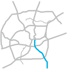
This page covers Interstate 37 east and south of downtown San Antonio from I‑35 to US 181. This freeway continues north of downtown as US 281 North. Length: 11 miles |
|
ADVERTISEMENT |
On this page:
 |
 |
 |
 |
| Overview | Roadway details |
Lanes | Access roads |
 |
 |
 |
 |
| Exits | Speed limits |
Special features and notes |
Traffic |
 |
 |
 |
 |
| Media gallery |
Construction projects |
Future plans |
History |
Overview
Interstate 37 serves San Antonio's southeast side and diverges with US 181, the main link to exurban Wilson County. The freeway provides access to downtown San Antonio, the Alamodome, St. Paul Square, the Brooks redevelopment (formerly Brooks City-Base), the San Antonio Missions Trail National Park, Texas DPS Regional Headquarters, San Antonio State Hospital, and San Antonio State School. The freeway is also a primary route to the Eagle Ford oilfields south and southeast of the city.
Between downtown and SE Military Dr., the freeway is fronted mostly by residential areas. From there to US 181, most of the immediate frontage is undeveloped.
Roadway details
| EXITS |
Click here for a list of I‑37 exits. |
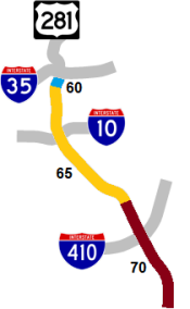
| SPEED LIMITS | |
|
|
|
|
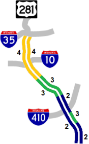
 concurrent from I‑35 to Loop 410
| TRAFFIC | |
|
|
Heavy in the downtown area. Heavy to moderate south of I‑10. Recurring morning congestion occurs northbound from I‑10 to I‑35 and also in the vicinity of Loop 410. 
|
|
| AVERAGE DAILY TRAFFIC | |||||||
| LOCATION | 2002 | 2012 | 2017 | 2019 | 2021 | 2022 | '12-'22 % CHG |
| S of I‑35 | 132,000 | 131,000 | 159,575 | 159,184 | 140,216 | 127,190 | -2.91% |
| N of Cesar Chavez Blvd. | 114,000 | 112,000 | 135,577 | 136,515 | 132,577 | 120,260 | +7.38% |
| N of I‑10E | 135,259 | 122,693 | N/A | ||||
| N of Fair Ave. | 104,000 | 120,000 | 137,758 | 138,357 | 133,629 | 121,215 | +1.01% |
| N of Hot Wells Blvd. | 73,000 | 90,000 | 102,196 | 103,713 | 101,143 | 91,747 | +1.94% |
| N of SW Military Dr. | 57,000 | 76,000 | 113,023 | 86,136 | 83,950 | 76,151 | +0.20% |
| N of Loop 410 | 46,000 | 62,000 | 88,867 | 74,157 | 86,872 | 69,731 | +12.47% |
| S of Loop 410 | 57,000 | 69,000 | 82,801 | 84,749 | 91,941 | 83,400 | +20.87% |
(NOTE: In 2021, TxDOT changed the location of several traffic counting stations. New stations will show no history prior to 2021.)
|
ADVERTISEMENT |
Media gallery
Click here for historical photos of this freeway.
Click here for video of this freeway.
Construction projects
There are currently no major construction projects in this corridor.
Future plans
TxDOT has plans to convert the I‑37/SE Military Dr. intersection to a Diverging Diamond Interchange (DDI) and add an exit to City Base Landing. That project is currently anticipated to start in 2025.
The Alamo Area Metropolitan Planning Organization has an unfunded proposal in its 25-year plan to expand I‑37 from four to six lanes from Loop 410 south to the Atascosa County line.
History
This route was originally named the "Southeast Expressway". The section south of I‑10 is was named in 1994 for Lucian Adams, and the section north of I‑10 is named for William J. Bordelon; both are World War II Medal of Honor recipients. Interstate 37 was authorized by the Texas Transportation Commission on October 1, 1959.
While all of San Antonio's other freeways have sections that were upgraded from existing US highways, I‑37 was entirely a "new location" route. US 181 was adjusted to end at I‑37 when it opened; it had previously continued into the city along S Presa St.
- 1956: This general route first proposed for US 181.
- 1957: Interstate 37 from San Antonio to Corpus Christi added to national Interstate system.
- 1959: Route finalized along with that of I‑10 East.
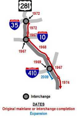
- 1967: The section from Florida St. to I‑10 and the section from SE Military Dr. to US 181 opened.
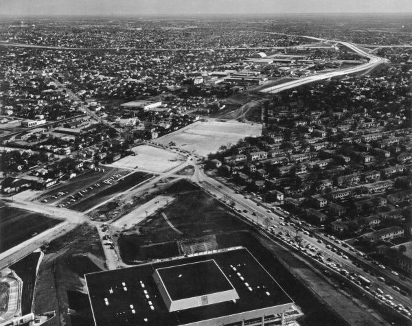
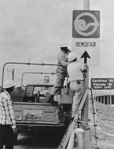
- 1968: The segment from I‑10 to SE Military Dr. completed. The right-of-way between Florida St. and I‑35 adjacent to downtown was paved for use as parking for HemisFair, and the I‑37 mainlanes coming from the south fed directly into the parking lot.
- 1969: The interchange at Loop 410 was completed.
- 1972: The section from Florida St. to I‑35 completed.
- 1974: The section from US 181 south to Loop 1604 completed. The overpasses for the mainlanes and several access roads along this section appear to have been completed around 1968, but the mainlanes themselves were not completed until this time.
- Late 1980s: Access roads along most of the route south of I‑10 proposed but never built.
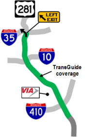
- 1995: TransGuide coverage added from I‑35 to Fair Ave. as part of the original TransGuide project.
- 2009-2010: Work to raise the overpasses at Pecan Valley Dr., S New Braunfels Ave., and Southcross Blvd. was completed.
- 2009: The section between Loop 410 and US 181 was widened and improved to better facilitate hurricane evacuations from Corpus Christi and South Texas.
- 2010: The cloverleaf interchange at SE Military Dr. was removed and replaced with a standard diamond interchange.
|
More historical photos of I‑37 are available here. |