|
|
|
|
|
This page last updated May 15, 2025 |
By the mid 2010s, congestion had become a significant problem at the Bandera Rd. (SH 16)/Loop 1604 intersection. So planners began looking for potential remedies. After reviewing multiple options, engineers settled on a Displaced Left Turn (DLT), a type of "innovative" intersection that had shown good results in several implementations nationwide and had recently been implemented in San Marcos. Computer modeling of the Bandera/1604 intersection predicted as much as a 75% reduction in delay with a DLT.
Construction begin in September 2017 and the intersection opened to traffic on April 28, 2019. This is the first (and currently only) DLT in San Antonio, but several more are planned.
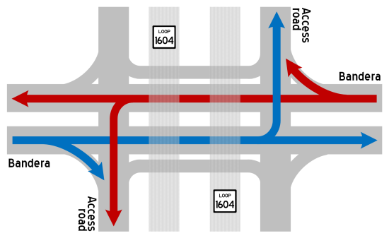
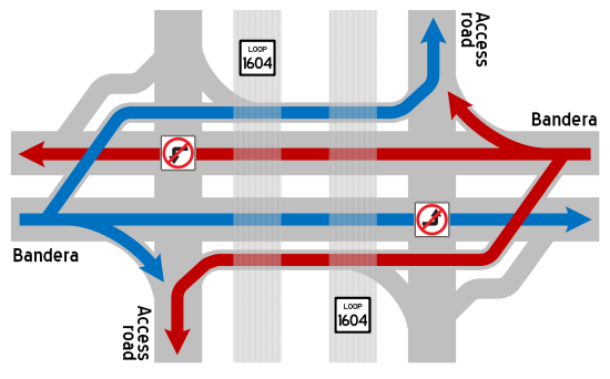
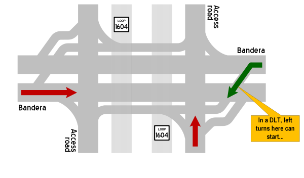
With the new displaced left turn, traffic is no longer allowed to make a left turn from Bandera Rd. to Loop 1604 where it typically would. (See the diagrams below for a depiction of these changes.)
CONVENTIONAL INTERSECTION (PREVIOUS)
TRAFFIC FLOW FOR BANDERA RD.
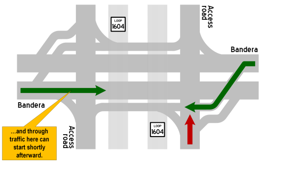
DISPLACED LEFT TURN INTERSECTION
TRAFFIC FLOW FOR BANDERA RD.
|
ADVERTISEMENT |
Also, because the crossover angle for the left turns in a DLT is more gentle than for a regular left turn, a bit more left-turning traffic is typically able to get through in the same amount of time as compared to a conventional intersection.
These diagrams should help to illustrate the descriptions above. Note that for simplicity, the DLT diagrams below only show the sequence for one half of the flow on Bandera and are based on a "typical" DLT flow.
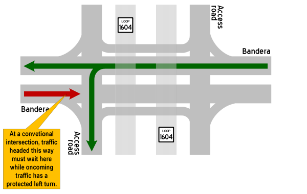
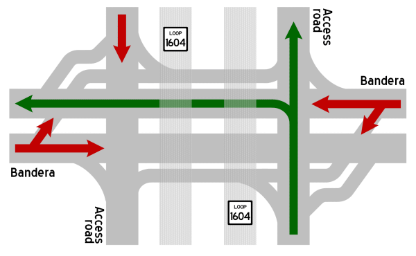
CONVENTIONAL INTERSECTION (TYPICAL)
Only one direction of traffic can go through the intersection at a time.
DISPLACED LEFT TURN INTERSECTION
Both directions of traffic on Bandera can go through the intersection at the same time.
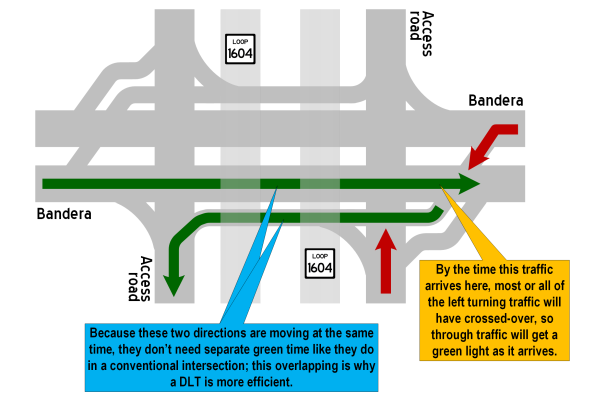
This "continuous flow" of traffic in both directions means that only one green signal phase is needed for both directions on Bandera instead of the two phases required at the conventional intersection. The time saved from having only one phase can then be distributed to extend the green time for everyone, thus moving more traffic through the intersection on each cycle without having to increase the overall cycle length. For example, if each of the conventional intersection phases for Bandera was 45 seconds long and the DLT allowed one of them to be eliminated, that could allow 15 seconds of green time to be added to the remaining three phases. This means that, in this example, roughly 33% more traffic can get through the intersection per cycle. (In reality, the extra time would more likely be allocated in varying amounts as dictated by traffic volumes.) Alternatively, the time from the eliminated phase could be dropped from the cycle altogether, which means the signals will cycle more often in a given period compared to a conventional intersection, again allowing the intersection to move more traffic in the same period of time.
 What is a signal phase? A signal phase is the green time assigned to a specified movement or collection of simultaneous movements in a traffic signal cycle. In other words, when the signal is green for a specific movement (straight through, left turn, etc.), that's a signal phase. When it changes to red and another movement gets a green signal, that's another phase. The complete rotation through of all of the phases is a cycle. |
An important note: Observed signal phasing and timings at the Bandera/Loop 1604 intersection vary from what is described above, but the underlying concepts are still the same. (See example timings illustration below. Signal timings are simplified and for illustrative purposes only and do not represent actual timings. Timings will vary depending on the time of day and traffic demand.)
|
EXAMPLE TIMINGS Below are simplified timelines showing example signal phase timings for each movement in the Loop 1604/Bandera Rd. intersection. Note that these timings are simplified for illustrative purposes only; they do not represent actual timings, and the actual phasing is a bit more complex and can vary throughout the day. Be sure to read the explanation above. |
|
Conventional intersection Only one direction can go at a time. If each direction gets 45 seconds of green time, that's a total cycle time of 180 seconds. 
|
|
DLT intersection 
|
Note that the example timings above show separate phases for each access road (blue and purple blocks). However, the DLT configuration allows the access road phases to also be overlapped, i.e. both access roads could have a green simultaneously. In this scenario, traffic turning left from the access roads would be stopped on Bandera between the access roads for a short period of time. It would then released at the same time as through traffic on Bandera. This generates additional efficiency. However, turning volumes at this location are generally too high for that configuration to work during most of the day (i.e. there isn't enough room under the overpasses to store that much traffic), so each access road instead has a separate phase with a partial overlap, i.e. the tail end of traffic making the turn in one direction (typically the northbound access road turning to northbound Bandera) gets stopped under the overpass. They will get a green and be gone well before the access road they turned from gets a green again.
Here is an animation that puts it all together. Note that this animation is greatly simplified and represents the "typical" DLT flow. The phasing at Bandera and Loop 1604 differs somewhat from what is shown below and is discussed in more detail below.

After simulating traffic flows, engineers opted to customize the signal phasing at this intersection in order to better synchronize the signals at 1604 with the signals at Quincy Lee/Stonecroft. This customization changes the sequence so that the two Bandera displaced left turns don't run concurrently, but instead run independently following the corresponding near-side access road phase. Rearranging the signal phases this way allows traffic leaving the DLT headed south on Bandera to encounter a green light at Quincy Lee/Stonecroft, and also permits the synchronization of the green signals for northbound Bandera at Quincy Lee/Stonecroft and 1604. Because of the signal cycle timing required to handle traffic at Quincy Lee/Stonecroft, using the typical DLT phasing at 1604 would not have allowed signal synchronization in both directions. Different options to re-configure the signals at Quincy Lee/Stonecroft to accommodate the typical DLT phasing would have resulted in shorter and disjointed phases there, which would have resulted in increased congestion for those side streets and the left turns from Bandera. Changing the DLT phasing was a win-win.
The main drawback of this customization is that the displaced left turn traffic from northbound Bandera to southbound Loop 1604 arrives at the southbound access road at the same time as the southbound through traffic on the access road is crossing Bandera. During peak periods, this results in a crowded merge and some slowing on the access road as a result. This is generally only an issue during the afternoon rush hour and was considered to be an acceptable trade-off for the overall improved efficiency. Should it become problematic in the future, the merge lanes on the access road can be extended.
|
ADVERTISEMENT |
Improvement statistics
Safety has also generally improved at DLT intersections studied with serious crashes decreasing 34% at the Baton Rouge location (total collisions were down 25%) and crashes at and near a DLT in Utah were reported to have decreased a whopping 60%.
A Federal Highway Administration study took 96 drivers who had never navigated a DLT before and used a simulator to test how they handled three different DLT signage and marking treatments. Only five drivers missed the left turn, and only one of them made an illegal left turn at the main intersection. Only one driver stopped at the wrong place on the intersecting road at the displaced left crossing. No drivers went the wrong way at the left turn crossover, which seems to be the maneuver that many people expect will happen.
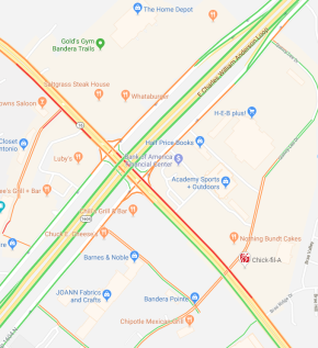
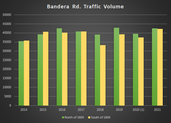
With regards to congestion, the author of this website observed that afternoon peak backups on northbound Bandera Rd. between Quincy Lee and Loop 1604 completely disappeared after the DLT opened (an outcome that continues to time of this writing). An analysis of Google Maps data showing "typical" traffic at that intersection prior to and after the DLT showed a marked decrease in congestion levels.
BEFORE
|
AFTER (MARCH 2020) 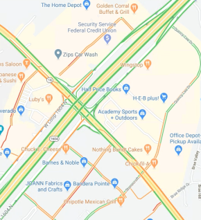
|
AFTER (MARCH 2025) 
|
In the 2025 "after" snapshot, we can see that overall, congestion levels remain substantially improved compared to before with no notable increases in congestion more than five years after the intersection went into operation.
As for safety, an unofficial review of crash statistics at this intersection by the author of this website showed that crashes decreased markedly in the eight months after the DLT opened as compared to the same period in previous years. There was a 44% decrease in total crashes compared to the period the previous year, and a 36% decrease in total crashes over the average of that period for the previous five years. Crashes categorized as "intersection-related" were cut in half during the eight months after opening compared to the prior year and were down 44% over the preceding five year average. A preliminary report from TxDOT on the crash data at this intersection also noted a 44% decrease in crashes.
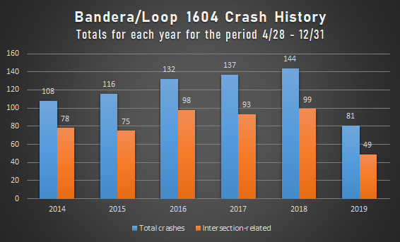
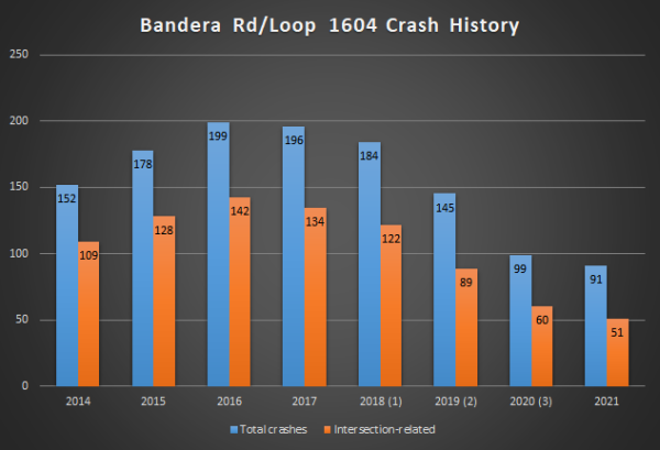
An updated review at the end of 2021 showed the reduction in crashes continued. Even with traffic volumes in 2021 back to pre-COVID levels, the number of crashes in 2021 was less than half of those in 2016 and 2017, years with comparable traffic volumes prior to construction. Furthermore, intersection-related crashes decreased from 70% of all crashes in 2016/2017 to 56% of all crashes in 2021.
Footnotes: (1) [2018] Intersection under construction; (2) [2019] DLT opened on April 28, 2019; (3) [2020] Traffic reduction due to COVID
Footnotes: (1) [2020] Traffic reduction due to COVID
FAQ
- This looks difficult to navigate. It will cause lots of crashes.
While it may look complicated on the schematics, it's actually fairly easy to navigate on the ground. Crash data at this intersection show a significant reduction in crashes after the intersection opened. - Why does the displaced left turning traffic onto southbound 1604 have to merge with through traffic coming down the access road?
This is not typical for a DLT (and indeed doesn't happen on the northbound side), but given the traffic patterns here, this phasing makes the intersection work better overall and synchronizes better with the signal at Stonecroft/Quincy Lee. This is explained in the "Customized Bandera/1604 signal phasing" section above. The rationale gets pretty complicated, but here it is in as few words as possible:
- The typical DLT phasing would result in the access road getting a green as northbound traffic on Bandera was arriving at Loop 1604 due to the timing of the Quincy Lee/Stonecroft signal. To prevent that, the Quincy Lee/Stonecroft signal could be adjusted, but that would then result in southbound Bandera traffic getting a red at Quincy Lee/Stonecroft just as it was arriving from the DLT. Any other adjustments to the Quincy Lee/Stonecroft signal to coordinate it with the typical DLT phasing would require extra signal changes and odd phasing that would make it much less efficient, thus increasing congestion on those side streets as well as the left turns from Bandera.
- If the southbound access road traffic was held until the displaced left turns cleared there, it would create wasted time in the intersection, which would increase congestion and undo much of the improvements provided by this project.
- Conversely, holding the displaced left turns until the access road traffic cleared would also create wasted time or would require stopping the traffic that had just turned left from the access road in order to let the left turns cross over. The backup from that would then would interfere the subsequent release of the southbound Bandera through traffic.
- To summarize, changing the DLT phasing to the way it is allowed both directions of Bandera to be coordinated with the Quincy Lee/Stonecroft intersection, and the southbound access road merge was considered to be a good trade-off for the overall efficiencies provided by that.
So as you can see, getting those two intersections synchronized is quite complex! The resulting merge condition on the southbound access road, while not ideal, is manageable, especially if motorists coming from northbound Bandera who want to turn into the first driveway (near Taco Cabana) instead merge smoothly over to the right, then use one of the other driveways further down and backtrack within the shopping center as needed. Should the situation there warrant, the merge lanes can be extended. - How does this crazy design improve traffic? How does adding even more traffic signals help?
This intersection design improves traffic because it moves left turns out of the way of oncoming traffic prior to the intersection. As a result, both directions of traffic (straight and left turning) can move during the same green phase. A conventional intersection requires two green phases for this — one for the straight through traffic, and another one for the opposing left turning traffic. Because both of those directions move at the same time in a DLT, one green phase can used for both, allowing the other phase to be removed from the signal cycle and the time formerly used by that phase reallocated to the other phases; this moves more traffic through the intersection in the same amount of time.
People often see traffic signals as an impediment, but it's how they operate that matters. All of the extra signals at a DLT are needed to regulate flow through the extra junctions created in this intersection type. Those signals, however, are all tightly coordinated by the same controller so that traffic flow is synchronized through the intersection. Any time spent stopped at one of those new signals should be minimal and more than offset by the overall reduced delay at this intersection. - Why not build flyovers instead like the ones at Bandera and Loop 410?
Across the country, traffic engineers have discovered that innovative intersections like this can produce good congestion relief and safety at a fraction of the cost and construction time of flyovers and other traditional grade-separated solutions. This allows the limited transportation dollars to be saved and used for other needed projects. - Why are there signals to enter the turnarounds?
This is because the same roadway is also used by the displaced left-turning traffic from Bandera. A signal is necessary to prevent collisions due to that unexpected traffic. - How is this different than the intersection under construction at Blanco and Loop 1604?
The DLT is similar to the Diverging Diamond (DDI) interchange being built at Blanco and 1604 in that they are both considered to be types of "innovative" or "alternative" intersection designs that make signalized intersections function better by removing the inefficiencies caused by protected left turns. Both intersection designs do this by moving the left turns over to the other side of the road and out of the way of oncoming traffic. However, in the DLT, it is just the left turns that are shifted to the other side of the road, whereas the DDI moves both left-turning and through traffic over. A DLT has its crossovers further away from the main intersection and requires more signals and right-of-way than a DDI. Also, the DLT does not block through-traffic on the access road like a DDI does. Finally, a DLT does not eliminate the conflicting left turns from the access roads to the cross street like a DDI does. - Are any other DLTs planned in San Antonio?
Yes, two other DLTs are currently planned: one at Loop 1604 and Culebra and one at Loop 410 and Cornerway Blvd/WW White Rd., as well as a partial DLT (one direction only) at US 281 and Basse. A partial DLT opened in 2023 at I‑35 and FM 306 in New Braunfels. Other varieties of innovative intersections are also being planned for other locations; see the innovative intersections page for more info. - Who came up with this cockamamie design? This doesn't work and is just a waste of money.
The DLT design has been around for several decades and is in use in several dozen locations in the US and internationally, and has a proven track record of improving traffic when it has been implemented. It is one of several types of "innovative" or "alternative" intersection designs being implemented across the country at intersections where improvements from conventional expansions will be short-lived but where conditions do not warrant more expensive traditional upgrades such as flyovers.
TxDOT selected this design for this intersection after studying multiple other options. Computer modeling showed this design provided significant improvement in traffic flow with as much as a 75% reduction in delays, and the actual data after the intersection opened shows substantial decreases in crashes and congestion levels.
Video
Here is a drive-through video of the intersection shortly after it was opened to traffic:
Other sites of interest
|
|
Wikipedia - Continuous-flow Intersection https://en.wikipedia.org/ |
|
|
TXDOT - Continuous Flow Intersections Fact Sheet http://ftp.dot.state.tx.us/ |
|
|
FHWA - Displaced Left Turn Intersection Informational Guide https://safety.fhwa.dot.gov/ |
|
|
DLT Case Study - Bangerter Highway in Salt Lake County (Utah) https://www.youtube.com/ |