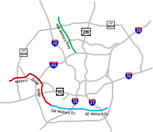
Military convoy between San Antonio and Camp Bullis ca. 1935
This is on today's I‑10 at UTSA Blvd. looking north.
(Photo courtesy of TxDOT)
No compendium of road history in San Antonio would be complete without a discussion of the military. Given the armed forces' key role in the area's economy, as well as strategic considerations, military mobility has played an integral part in the area's road development going all the way back the Spanish Colonial era.
First bits of a loop
The first instance of this in modern history came in the 1930s when the county and state worked together to identify a route for the first section of a loop proposed in the 1932 Arneson Plan for state highways in Bexar County — specifically, the segment from Kelly Field to Brooks Field. Arneson's plan made specific mention of the need to separate civilian and military traffic, and one of the stated purposes of his proposed loop around San Antonio was to allow military convoys to circumnavigate the city.
On his proposed loop, much of the segment connecting Kelly and Brooks was actually up to a mile south of Military Dr. But around 1937, the state worked with the county to build the first segments of what would become Loop 13 from New Laredo Highway to S Presa St. mostly along the current alignment. It appears the first section to open was between S Flores and S Presa. In late 1938, the route was extended west from New Laredo Highway to the railroad, with an overpass completed in 1940. From there, it appears the road continued to the west as a county road, arcing north of today's route before crossing Salado Creek and feeding into Old Pearsall Rd.
The route was designated as Loop 13 in September 1939. Around 1943, it was extended west from Pearsall Rd. through the new San Antonio Aviation Cadet Center (later renamed Lackland AFB) to US 90, and east from Brooks Field to WW White Rd. Around 1946, Loop 13 was extended north along WW White to US 90 East. WW White continued north of there as a county road along today's Springfield Road to the Seguin Road (today's FM 78), which connected the eastern end of Fort Sam Houston to Randolph Field, thus providing more-or-less direct connectivity between the five installations. Seguin Road was sometimes called "Randolph Field Road" because of its connection to that installation.
Access to Randolph
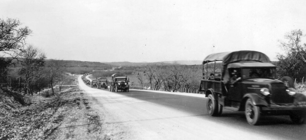
Before the mid '30s, Seguin Road (most of which is today's FM 78) was SH 3, the main highway between San Antonio and Houston, and therefore provided a direct major state highway connection right at Randolph's main gate. However, in the mid '30s, the state built a new route for SH 3 several miles to the south of Randolph (that route is today's I‑10). Although the Arneson Plan had also proposed a new, straighter route from Randolph to the new SH 3, it seems the state nixed that idea at some point in favor of a new road to connect the installation with nearby US 81/SH 2 (today's I‑35.) Built in 1935, that route is today's SH 218/Pat Booker Rd., which, along with US 81, provided a new high-speed link to Fort Sam Houston. It was named for Francis Pascal "Pat" Booker, an Army Air Corps captain who died in a crash in September 1936. In the 1950s, the state studied an overpass for Pat Booker Rd. over FM 78 and the adjacent railroad and into Randolph, but for reasons unknown, it never came to fruition. (
Special thanks to Michael P. Hoffman for some of the history of Pat Booker Road.)
Proposed overpass at Randolph main entrance ca. 1955
(Document courtesy of TxDOT)
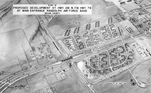
Harry Wurzbach Road
Prior to the US entering WWII, the military began working with states and local governments to improve access to local military installations. To that end, the "Camp Bullis-Ft. Sam Houston Access Road" — renamed the "Harry Wurzbach Military Highway" (and often referred to at that time simply as "Military Highway") — was built by the county, state, and Works Progress Administration around 1943 to directly connect Fort Sam Houston to Camp Bullis. Its purpose was to replace a circuitous route through the city via US 87/Fredericksburg Rd or Blanco Rd. The new road encompassed what's now Harry Wurzbach Rd., NW Military Hwy., and the stretch of today's Loop 410 in between, part of which at the time was a road named Zercher Rd. This linkage is why Harry Wurzbach and NW Military bend toward each other at Loop 410. The route included overpasses where it intersected US 81 (Austin Hwy.) and US 281 (San Pedro Ave.) to safely separate the military and civilian traffic streams, as well as an overpass over the railroad west of Broadway.
After WWII ended, federal funding to maintain the road ceased, and large parts fell into disrepair. The state, already planning to extend Loop 13 across the east-west segment of the route, took over maintenance of that section, and eventually also decided to take over the section from Loop 13 to Camp Bullis with the initial intent of using it as a bypass for US 87. (The bypass plan later was dropped, but the state retained that section.) However, they determined there was no value to the state to take over the section from Loop 13 to Ft. Sam Houston, so the city and county assumed it.
Map showing status of Harry Wurzbach Military Highway construction in 1943
Also note the early proposal for Loop 410 (referred to as "Military Loop" in the notes) west of
NW Military — it would have connected to US 87 (Fredericksburg Road) just north of Wurzbach Rd.
(Source: Texas State Library and Archives)
War Highways
Also around 1942, present-day Camp Bullis Rd. between today's I‑10 and Camp Bullis was built by the county in cooperation with the Highway Department to replace the existing narrow and winding road connecting the installation to US 87. The road was designated "War Highway 2", one of 21 such routes around the state built to support the war effort. Those designations were dropped six months after the war ended.
Map of the various military roads in San Antonio around 1945 overlaid on today's freeway network
Loop 13 grows
Around 1950, a new segment of Loop 13 was established along today's Loop 410 from Austin Hwy. westward to San Pedro Ave. (then US 281), subsuming part of the Harry Wurzbach Military Hwy. Around 1953, Loop 13 on the East Side was extended north from US 90 by straightening WW White Rd. and constructing an overpass over FM 78 and the railroad tracks, then continuing further north along present-day Loop 410 and I‑35 to meet US 81 (today's Randolph Blvd. and Austin Hwy.) near the community of Fratt. This connected it with the section of Loop 13 headed west. During the war, there had been a short-lived proposal for this northeastern section of the loop to head more northwesterly from its crossing at FM 78 to cross Rittiman Rd. at Salado Creek, then follow Salado Creek to Austin Hwy., and then veer northwest to meet Harry Wurzbach near today's Loop 410. It was thought this would better facilitate military traffic, but it was ultimately nixed since the state had already invested substantially in the route north to Fratt, and because the increase in access it would provide for the military was determined to be marginal.
Military Drive West
At one point around 1950, it does appear planners briefly considered extending Loop 13 north and northeast from its terminus at US 90 partially along what's now Military Drive West. However, those plans changed when it was determined that Military Dr./Loop 13 on the South Side had become too urbanized for easy expansion, so a new route for what would become Loop 410 was plotted further south along Chavaneaux Rd. and west of Lackland along Dwyer Rd., and then extended north and northeast from there. So instead, the first section of Military Drive West north of US 90 was built in 1961 mainly to serve new residential areas sprouting up north of Lackland. Over the years, it has been extended further north and west with an underpass for it at Loop 410 built in 1982. Coincidentally, it now runs past the San Antonio campus of the National Security Agency, providing yet another military context for the road. County officials did ask the Texas Transportation Commission in 1968 to extend Loop 13 along the route from US 90 to Potranco Rd., but the request was apparently denied.
Medina Base Road
Just like with Fort Sam and Camp Bullis, a need arose to connect Kelly Field and Medina Base — in this case, to provide a direct route to transfer atomic weapons and other materials stored at Medina to and from the airfield at Kelly. So in 1955, the Medina Base Road was built. However, instead of intersecting Old Pearsall Rd. as it does today, it originally turned northeastward just west of Old Pearsall Rd., crossed Military Dr. and Leon Creek, and intersected with Westover Rd. on the west side of the airfield. While that section of the road is long gone now, the bridge at Leon Creek is still there today. The rest of the route to the west was essentially the same as it is today.
The road was closed during military freight movements between the bases, but was open for use by civilian traffic the rest of the time. When Loop 410 in that area was built around 1960, federal officials mandated that it not include an interchange with Medina Base Road so as to avoid conflicts with the military traffic and more easily facilitate those road closings. An interchange was subsequently built in the late '60s after the weapons center at Medina was transferred to another facility near Amarillo.
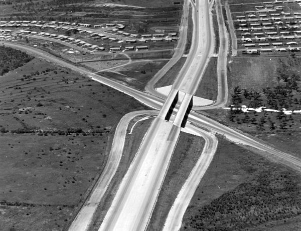
Loop 410 at Medina Base Rd. ca. 1961
Note that the frontage roads do not cross or intersect with Media Base Rd.
This was done to facilitate closing of Media Base Rd. for military operations.
(Photo courtesy of TxDOT)
Request to close Military Dr. through Lackland
Around 1958, the military made known their desire to close Loop 13/Military Dr. through Lackland AFB due the conflict and difficulties it caused with movement between the two sides of the base. However, this elicited a deluge of protests and objections from the community, including a resolution against the proposal by Bexar County. Still, the Highway Department considered it, possibly in conjunction with a land swap for right-of-way needed for the US 90 expressway along the north side of the base, and a rerouting of Loop 13 along Medina Base Road or FM 2536/Pearsall Rd. However, the opposition from the community, and a failure to come to an agreement with the federal government over shared costs, ultimately scuttled the plan.
Access to Kelly
By the mid '50s, Kelly AFB had become a major civilian employer in the area. Despite efforts to manage traffic with staggered shifts, congestion had become a serious issue. Major General Clements McMullen recognized the impact the congestion was having and worked tirelessly with local officials to build a "four-lane superhighway" from the Northwest Side to the base. The outcome was a plan to expand and extend what was then Stephenson Road from Culebra Road south to the base. The six-lane arterial opened in 1954 and was renamed in General McMullen's honor.
Shortly thereafter, with the impending US 90 expressway passing near the base, Kelly officials began investigating the possibility of a direct expressway connection, and forwarded a request for the "Kelly Access Road" to the federal Bureau of Public Roads (BPR) in 1957. However, while the BPR concurred with the need for such a route, it was determined that it was not eligible for federal Defense Access Road (DAR) funds, a position that was challenged by local officials. Still, the city and state took the lead in attempting to secure funding for the road. But, city voters narrowly rejected a bond package to purchase right-of-way for it and other expressways in June 1960 due controversy over a couple of the other routes included in the package. The bond package was tweaked, with park improvements added, and voters approved it in January 1961 by a 5-1 margin. Local and state officials continued to press for DAR funding for construction, but it's unclear whether they were successful. Regardless, construction began on the route in September 1964 with a "groundblasting" ceremony that concluded with officials pressing an oversized plunger to detonate a simulated missile warhead, symbolizing the importance of access to Kelly AFB to the nation's security during the Cold War. The road was completed in early 1967.
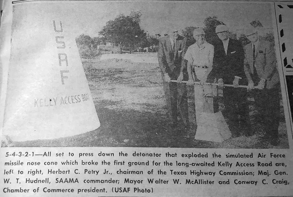
"Groundblasting" ceremony for General Hudnell Drive
(Source: Kelly AFB Flying Times)
Just passing through
Local military installations have also played a role in other local road history. The first state highway to the northeast (SH 2 to New Braunfels, Austin, and beyond) crossed through Ft. Sam Houston, which was an open post until 2001. Heading north along N New Braunfels Ave., it passed through Ft. Sam, then turned east onto Eleanor St. and followed Old Austin Rd. along the edge of the post, then crossed through Ft. Sam again near the old BAMC and onto today's Harry Wurzbach before continuing northeast onto Corinne Dr., Austin Hwy., and Randolph Blvd. SH 2 continued to pass through Fort Sam until the late '20s when the route was changed to use Broadway and Garraty Rd. instead. It's unclear if that change was made to avoid traversing the post or if it was to reduce the complexity of the downtown end of the route; perhaps it was a bit of both.
Before the current runway was built at Kelly Field during World War II, Frio City Rd. connected to today's Old Pearsall Rd. at SW Military Dr. (looking at a map, you can see how they line up) and was also part of SH 2, which to the south was the route from San Antonio to (you guessed it) Pearsall and on to Laredo. Part of that road is now the section of General Hudnell Dr. in Port San Antonio. When Kelly Field was first established at the height of World War I in 1917, it occupied the wedge of land between that road and the railroad tracks along Quintana. A second military field, unimaginatively called Kelly Field #2, was built almost immediately thereafter in the area immediately northwest of the original site, with SH 2 then dividing the two. New Laredo Highway was then built in the late '30s per the Arenson Plan to replace the route through Kelly. During WW II, the two airfields, then known as Kelly Field and Duncan Field, were combined and expanded, and the remaining road through the consolidated Kelly Field was truncated in order to build new runways and hangars.
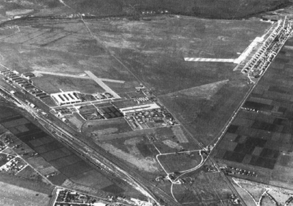
Duncan (left) and Kelly (right) Fields 1935
This view is looking to the southwest; Leon Creek is at the top.
The road in the middle of the two air fields is the old SH 2.
(Source: United States Air Force via
Wikipedia)
Which Military?
San Antonio is known for having an unusual number of street naming idiosyncrasies that confound locals and visitors alike. One of those is that there are three distinct roadways with "Military" in their name: SE/SW Military Drive, Military Drive West, and NW Military Highway. Here is the breakdown of each:
- SE/SW Military Drive: This roadway, also designated as Loop 13, is the main "drag" of the South Side of San Antonio running from S WW White Road near Loop 410 westward crossing both I‑37 and I‑35. It becomes Military Drive West (see next bullet) somewhere near Whitewood St. just west of Pearsall Rd. S Flores St. is the dividing line between SW and SE Military Dr.
- Military Drive West: Military Drive West, also sometimes called W Military Dr., continues north from the end of SW Military. If you're not paying attention to the signs, you won't even notice the name change. It runs through the middle of Lackland AFB before crossing US 90 (where the Loop 13 designation ends), SH 151, and Loop 410. For over three decades, it ended at Potranco Rd. In the mid '80s, another leg of Military Drive West sprung up further west between SH 151 and Grossenbacher Rd, gradually creeping eastward and southeastward toward Potranco. The gap was finally closed in 2020.
- NW Military Highway: This is a completely separate roadway from the others that runs from Loop 410 through Castle Hills to Camp Bullis. Although it has the word "Highway" in its name, it's actually just a regular arterial roadway and is also designated FM 1535.
Coincidentally, Harry Wurzbach Rd. is another example of the local phenomenon of multiple roads with similar names: the three roads named Wurzbach. For more information on that and on the history of the Harry Wurzbach name, see the Which Wurzbach? page.