|
|
|
|
|
This page last updated February 20, 2024 |
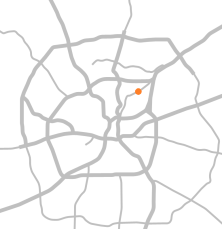
From the construction of Harry Wurzbach Rd. in 1943 until 2023, there was no direct connection between it and Austin Highway. Instead, Harry Wurzbach simply passed under Austin Highway with no interchange, and traffic wanting to transition between the two roads had to use an ersatz access road to the west or Eisenhauer Rd. to the east, and many people simply (and illegally) cut through the adjacent parking lots.
To finally remedy this disjointed connection, a project was started in 2020 and completed in early 2023 to provide a direct interchange between the two roadways. The new interchange includes San Antonio's first (and, to date, only) Single Point Urban Interchange (SPUI), and what appears to be the fifth one in Texas. The design, however, has been around since the mid-'70s and is in widespread use in many other states and overseas.
As they say, a picture is worth a thousand words, so see the diagrams below to help better visualize this.
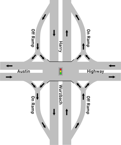
 What is a signal phase? A signal phase is the green time assigned to a specified movement or collection of simultaneous movements in a traffic signal cycle. In other words, when the signal is green for a specific movement (straight through, left turn, etc.), that's a signal phase. When it changes to red and another movement gets a green signal, that's another phase. The complete rotation through of all of the phases is a cycle. |
Note that at a SPUI, there is no straight-through traffic possible on the access roads, i.e. you are not able to exit Harry Wurzbach and then re-enter it by going straight through the intersection to the entrance ramp. At this location, since these are entrance and exit ramps instead of true frontage roads, there should be no need for anyone to go straight through anyway.
|
ADVERTISEMENT |
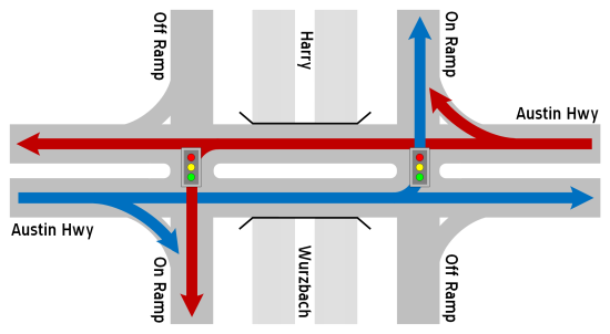
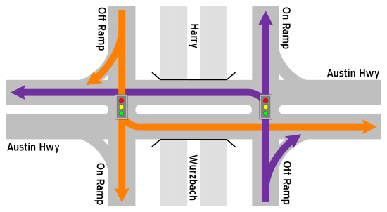
CONVENTIONAL INTERSECTION (TYPICAL)
TRAFFIC FLOW FOR AUSTIN HWY.
(This is how traffic would have flowed if they had used
a conventional intersection for the new interchange.)
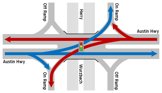
SINGLE POINT URBAN INTERCHANGE
TRAFFIC FLOW FOR AUSTIN HWY.
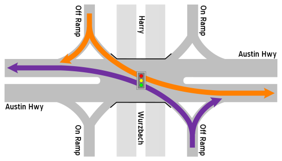
CONVENTIONAL INTERSECTION (TYPICAL)
TRAFFIC FLOW FOR HARRY WURZBACH RAMPS TO AUSTIN HWY.
(This is how traffic would have flowed if they had used
a conventional intersection for the new interchange.)
SINGLE POINT URBAN INTERCHANGE
TRAFFIC FLOW FOR HARRY WURZBACH RAMPS TO AUSTIN HWY.
FAQ
- This looks difficult to navigate. It will cause lots of crashes.
While it may look complicated on the schematics, it's actually fairly easy to navigate on the ground. A 1996 study of SPUI implementations found no significant difference in accident rates or severity compared to conventional intersections. A 2005 study found the same thing, although it did find that SPUIs had fewer collisions with injuries or fatalities. This design is in widespread use in the US and overseas and has a good track record.
Looking at this intersection specifically, in its first year of operation, there was exactly one crash reported. - So if this isn't necessarily safer than a conventional intersection, why do it?
Because the design means fewer signal phases, which means less delay for traffic. With safety being equal (no more or less dangerous), the reduced delay still produces a net benefit for this intersection type over a conventional intersection. - Are there turnarounds?
No, this intersection does not have turnarounds, but traffic wanting to turn around can easily do so at the intersection. - Why wasn't there a "real" intersection here before?
When Harry Wurzbach was first built back during World War II, its purpose was to connect Fort Sam Houston to Camp Bullis. There was no I-35 at that time, so Austin Highway, which was US 81, was the main highway from San Antonio to Austin and other points north, so it was quite busy. To avoid conflicts between military convoys on Harry Wurzbach and civilian traffic on Austin Highway, the overpass was built to separate that traffic. Because the area around this intersection was sparsely populated at the time, there was little demand to get from Harry Wurzbach to Austin Highway or vice-versa, so the ad-hoc routes to connect the two roads via Eisenhauer and the short access road to the west was determined to be sufficient, and that configuration endured. (You can read more about Harry Wurzbach Road's history here.) - Who came up with this cockamamie design?
The SPUI design has been around for several decades and is in widespread use in the US and internationally, and it has a proven track record of improving traffic when it has been implemented. It is one of several types of "innovative" or "alternative" intersection designs being implemented across the country. As this was a completely new intersection, the city and TxDOT were able to evaluate and select the best design for the location. Since there is no need to facilitate north-south through traffic on Harry Wurzbach at this intersection (as it goes under Austin Highway), a SPUI was a perfect fit.
Video
Here is a drive-through video of the intersection shortly after it was opened to traffic:
Other sites of interest
|
|
Wikipedia - Single-point urban interchange https://en.wikipedia.org/ |
|
|
TXDOT - Single Point Urban Interchange Fact Sheet http://ftp.dot.state.tx.us/ |